FUKUSHIMA, Japan (Reuters) - They scoop up soil from their gardens and dump it in holes dug out in parks and nearby forests, scrub their roofs with soap and refuse to let their children play outside.
More than three months after a massive earthquake and tsunami triggered a nuclear meltdown at a nearby power plant, Fukushima residents are scrambling to cope with contamination on their own in the absence of a long-term plan from the government.
... Read full article here
I was reading the Lucas Whitefield Hixson news site via the RadiationNews™ Google gadget when I saw his report on Fukushima Daiichi reactor I dry well. Just when I thought TEPCO was making progress in stabilizing Fukushima I the radiation spikes again, this time to all time highs. As the measurement device is labeled as "Defective meter" perhaps we can pray it is an erroneous measurement? Below is a screen grab which shows the latest data plot is from 7/3/2011 (Sunday JST):
Location:
Fukushima No. 1 nuclear power plant
Date:
Mar 15, 2011 (Tuesday) - 03 July 2011 (Sun)
The latest:
D / W: two hundred sixty-six Sv / h , S / C: 0.769 Sv / h
Situation
Defective meter
Date
D / W
S / C
7 / 03
266
0.769
7 / 02
42.0
0.770
7 / 01
34.2
0.773
6 / 30
43.2
0.775
6 / 29
33.8
0.775
6 / 28
35.4
0.764
6 / 27
51.0
0.793
6 / 26
35.0
0.798
6 / 24
41.6
0.801
6 / 23
54.3
0.803
6 / 04
250.0
0.889
6 / 03
222.0
0.898
6 / 02
209.0
0.909
6 / 01
185.0
0.919
5 / 31
59.0
0.928
5 / 30
41.8
0.936
5 / 29
225
0.944
5 / 28
215
0.950
5 / 27
63.8
0.959
5 / 26
43.7
0.958
5 / 25
215
0.987
5 / 24
192
0.997
5 / 23
201
1.01
NISA plant parameters have been published (when the reactor), the amount of nuclear radiation has been graphed.
You can check the daily water temperature, pressure and radiation dose of No. 1-5, Fukushima Daiichi nuclear power reactors.
As soon as the data is published and updated as the graph.
No. 4 spent fuel pool temperature for a value other than not being published, not a graph.
Meaning of the terms in the chart below. D / W stands for ... well dry. Containment vessel to the body. S / C ... stands for the suppression chamber. To the pressure suppression chamber.
※ The value of the graph shows the maximum absolute value of the day.
There does seem to be some progress made on TEPCO's cooling/water treatment system. According to the Daily Yomiuri, on Saturday the system was run and has decontaminated 3,580 tons of radioactive water, enough to provide 10 days worth of cooling.[1] Another sign of progress is that the cooling system is able to work off of decontaminated water in a closed loop, without requiring 2-3 tons of fresh water per hour being pumped in (sourced externally) as was previously required when the cooling system first started operating on June 27, 2011.[1, 2]
Also a broken hose with a large hole has been replaced which allows the resumption of reactor #5's cooling, which had been halted to do the repair.[3]
NHK World: TEPCO improves circulation cooling system [2]
When examining the right sidebar of the EX-SKF blog, where EX-SKF tracks the millimeters from the top of radioactive water drainage ditches to the water level, the distance from the top of the water to the top of the ditches is increasing, which means the amount of contaminated water pooling at Fukushima Daiichi is getting lower: another good sign.
Source: The Paltry Sapien
Date: 7/2/2011
by: Matthew Payne Baby Being Checked out for Radiation (c/o The Guardian)
UPDATE (7/3): The post below discusses what I see as the all-pervading mendacity surrounding the Fukushima accident, but The Atlantic Wire has an extremely important story, based on eye-witness interviews, that finally breaks TEPC0′s and the various governments’ blockades on what precipitated the accident (h/t to Joieau at Daily Kos for highlighting this story). We now know the standard story, that of a recovering plant being knocked out by tsunami wave taking out its emergency electrical generators, is the biggest lie. As the authors of the piece, Jake Adelstein and David McNeill note the truth may have been something very different:
But what if recirculation pipes and cooling pipes, burst, snapped, leaked, and broke completely after the earthquake — long before the tidal wave reached the facilities, long before the electricity went out?
(Reuters) - The Los Alamos nuclear weapons laboratory has ended a state of emergency and was taking small steps on Saturday toward reopening as the threat from a record New Mexico wildfire subsided.
But highlighting the need for continued vigilance, a squirrel sparked a small blaze on lab property on Saturday when it touched a transformer. That fire, which measured about an acre, was quickly extinguished, the lab said in a statement.
... Read full article here
Editor's Note: TA-53 (Technical Area 53) is where the squirrel mentioned above blew out the transformer, causing an electrical fire. TA-53 is outside any of the affected areas as shown in the MODIS or GOES fire detection maps provided by the USDA Forest Service.
Below is a map showing the Technical Areas and Material Disposal Areas together:
Source: care2 (make a difference)
Date: July 2, 2011 6:30 pm
by: by Beth Buczynski
Test results show that children living in Fukushima city during the March 2011 earthquake, tsunami and subsequent nuclear fallout may suffer from internal radiation exposure.
It is known that the Fukushima power plant, which is still under repair, sprang several radioactive leaks during the natural disasters, contaminating both sea and tap water, as well as soil of surrounding farm areas. Produce and milk exports were both halted in the weeks following the crisis for fear of spreading contaminated foods.
... Read full article here
On 7/1/2011 at approximately 10 AM CST, the privately owned Vanmann #30 agricultural levee was demolished via dynamite which caused a surge in the Missouri river level of several inches. The levee is just North of the Boyer Chute National Wildlife Refuge as per the following KETV Omaha Channel 7 video:
Based on the map in the above video, I mapped the busted levee (dynamite exploding icon) showing its relative positioning to Fort Calhoun Nuclear Generating Station (nuke icon at top) and Cooper Nuclear Station (nuke icon at bottom):
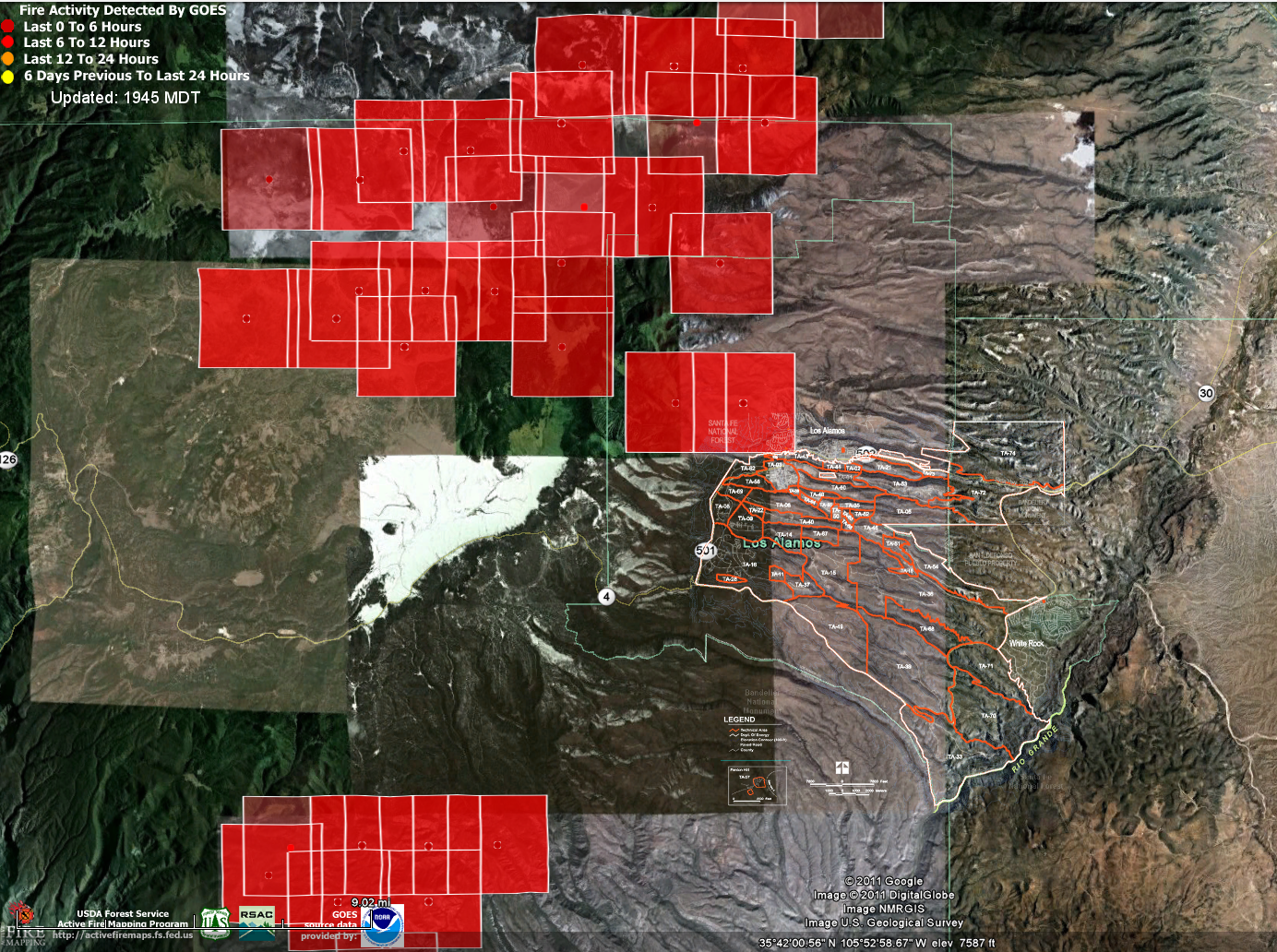
Friday 7/1/2011 I overlaid the MDA (Material Disposal Areas) and Technical Areas maps from Los Alamos Study Group on top of the GOES data set from the USDA Forest Service to get an idea of how far the Las Conchas wildfire had possibly encroached upon the LANL grounds, to see if the wildfire had possibly already contacted hazardous nuclear and/or chemical/explosive waste.
Here is the composite of the MDA and TA maps as one:
Here is the MDA+TA map overlaid on to the USDA Forest Service GOES data set:
Disturbingly, some of the older GOES yellow fire detection squares above (the square shows a potentially affected area, not that it is actually on fire) span several Material Disposal Areas: MDA-M, MDA-F, MDA-C, MDA-Q, MDA-P, MDA-N, MDA-R, MDA-S, MDA-Z, MDA-Y, MDA-K Notice that the yellow dot where I am assuming the actual detection occurs falls almost right on top of MDA-Y in TA-39 (Southeast portion of map).
So far the press does not report fires actually reaching any hazardous materials and releasing radiation in to the air.
Here is the MDA+TA map overlaid on the USDA Forest Service MODIS data set:
The MODIS data set shows older yellow detection squares being closest to MDA-M in TA-22, MDA-R in TA-16 and MDA-AB in TA-49.
Due to there not being many recent (red) detections close to the lab grounds it seems as if most of the danger has passed (at least according to GOES and MODIS). Most recent detections currently are primarily Northwest of Los Alamos National Lab.
Click here for previous maps from 7/1/2011 and source material (specific MDA and TA descriptions for example). Note that I only included 0-6 and 0-12 hour detections for that particular day as the older (yellow) detections are likely to be burnt out already.
Note that due to the top secret nature of Los Alamos National Lab, we do not know where all of the hazardous nuclear or chemical waste is located. Also, radiation can be released in to the air from burning trees which have grown near previous dump or test sites. Decades ago, barrels of nuclear waste were kicked-and-rolled in to unlined pits per Washington's Blog:
... For many years, one method of disposal was “kick-and-roll”. The back of a truck was brought to the edge of a hole and barrels of waste were kicked. Wherever the barrels rolled tow as their final resting place.
...
Following is a good (but several days old) interview with theoretical physicist Dr. Michio Kaku by KOATTV Action 7 News:
To understand why a raging wildfire near the Los Alamos National Laboratory is a big deal, you must understand how wastes were disposed.
AP writes today:
Los Alamos Canyon runs past runs past the old Manhattan Project site in town and a 1940s era dump site where workers are near the end of a clean-up project of low-level radioactive waste. The World War II Manhattan Project developed the first atomic bomb, and workers from the era dumped hazardous and radioactive waste in trenches along six acres atop the mesa where the town sits.
“The threat is pretty limited,” said Kevin Smith, the Department of Energy’s National Nuclear Security Administration site manager for Los Alamos, which over sees the lab. “Most of the materials have been dug up.”
But a report produced by the Alliance for Nuclear Accountability found:
Approximately 18 million cubic feet of radioactive and chemical solid wastes onsite were disposed of since 1943. “All of the radioactive waste and most of the chemical waste have been buried on the mesas of Pajarito Plateau where LANL is located. Radioactive liquid wastes were discharged to the canyons, initially with little treatment.”
For many years, one method of disposal was “kick-and-roll”. The back of a truck was brought to the edge of a hole and barrels of waste were kicked. Wherever the barrels rolled tow as their final resting place.
No protection was put in place to ensure contaminants did not spread from the barrel. It is not clear that today’s practices are more protective.
An estimated 899,000 curies of low-level transuranic [i.e. radioactive elements heavier than uranium, such as plutonium] wastes were buried at Los Alamos. It is difficult to estimate exactly the quantity of radionuclides buried onsite due to the inaccurate record keeping and alterations in the definitions of low-elevel waste in the intervening years. Disposal continues today in unlined pits and shafts, a practice declared illegal by the New Mexico Attorney General’s office in 2011...
Tons of plutonium were processed at LANL in the early years of development and again in the 1980s. After the Savannah River Site, LANL contains the second largest volume of plutonium-238 in the US nuclear weapons complex: this type of plutonium has a 90-year half-life, a very high activity and is extremely hazardous...
No wonder people have warned that the trees and soil in the areas surrounding the Los Alamos Laboratory may themselves now be radioactive. See this and this.
France
Explosion in Atomkraftwerk Tricastin
02. July 2011 19:20
Fire brought under control
Paris - In the southern French nuclear plant Tricastin it came to French media reports of an explosion. A fire had broken out, but this has been brought under control in the afternoon, it said on the website of the newspaper "Dauphine Libere." People were not injured. The explosion is said to have occurred in a transformer outside the nuclear zone. (APA)
A fire hit on Saturday afternoon, the transformer unit to stop the nuclear Tricastin in the Drôme. Large plumes of black smoke escaped but according to EDF, there will be consequences on the environment.
Posted July 2, 2011 at 21:23
A transformer of the power plant Tricastin, Saint-Paul-Trois-Châteaux (Drôme), exploded Saturday afternoon. The fire was quickly brought under control and the damage appears to no effect on the operation of the site.
"The fire was quickly extinguished." The prefecture of the Drôme, interviewed by leJDD.fr , has sought to reassure about an explosion on Saturday at the site of the nuclear plant Tricastin, in the commune of Saint-Paul-Trois-Chateaux. According to EDF, also contacted, an electrical transformer outside the nuclear zone, exploded around 15:30, causing the temporary shutdown of the plant. Material was then caught fire, releasing a large black smoke, which was witnessed by many residents and road. "The wind has not pressed the smoke on the ground and no motorist was annoyed," assures the prefecture.
Internal services of EDF responded immediately, locking the access to the site. Firefighters responded just minutes later to control the fire, confined at 15:55. "No one was hurt and there was no damage to the environment," says the prefecture.
Tricastin plant is subject to careful monitoring of the nuclear safety authority (ASN). The latter, in a 2007 report, stated that "the site had yet to make progress on the management of training, development permits and fire response times in case of fire that remain too long." A year later, the release of carbon, in June and September, and a leak of uranium in July, had caused great concern. ASN also announced last Thursday, have imposed new security requirements concerning the EDF reactor No. 1 of the plant. Commissioned in 1980, it might work for another ten years if the EDF gives the standards. The explosion took place Saturday in the Unit 1 power plant, fueled by the reactor 1.
Simplified map of the site of Tricastin (credit: Roulex_45/Wikipedia Commons).
GV - leJDD.fr
Saturday, July 2, 2011
There have in the past been safety concerns and incidents at this particular nuclear power plant, as per Reuters and Wikipedia. A recent Bloomberg article dated 7/1/2011 details that EDF (Electricite de France SA) France's largest operator of nuclear power plants was ordered to improve the Tricastin nuclear power plant's defense against natural disasters (floods, earthquakes and fires):
... EDF must reinforce the earthquake buffers at the Tricastin reactor as well as improve anti-flooding measures, according to a report released yesterday by the national atomic watchdog. Nobody from EDF could be reached for comment today.
...
The USDA Forest Service provides wildfire detection data which can be downloaded and viewed in Google Maps. In order to see the distance between the Las Conchas wildfire to the nuclear (or chemical/explosive) waste dump sites on the grounds of the Los Alamos National Lab I overlaid the inverted image of the above map on top of the Google Map with the fire detections data from the USDA Forest Service. Since the overlaid image is inverted (for better clarity) the original MDA map colors are transformed from red=>blue, green=>red, black=>white etc.
Here is the composite map, showing only detections 0-6 hours old (darker red) or 6-12 hours old (lighter red):
The data set I used was for GOES and obtained by clicking the "Current" link next to "Fire Detections:".
There is a light red square (6-12 hour old detection) just about touching the biggest blue blob (biggest red blob from the original Los Alamos Study Group Map).
Following is the Technical Area map from Los Alamos Study Group:
Source: Fairewinds Associates
Date: July 1, 2011
by: Arnie Gundersen
A video first released by TEPCO in April has been re-analyzed by Ian Goddard and appears to reveal a handle found atop a single nuclear fuel bundle. This raises more questions about the condition of any fuel still remaining in the Unit 3 fuel pool.