Source: Global Security Newswire
Date: Tuesday, July 5, 2011
The Los Alamos National Laboratory in New Mexico is due to open on Wednesday, more than one week after a record-setting blaze in the state forced the nuclear weapons site to suspend operations, facility Director Charles McMillan said on Sunday (see GSN, July 1).
“Los Alamos National Laboratory appears to have escaped serious damage from the Las Conchas fire,” McMillan wrote in a memo to personnel. “We are grateful for the tremendous efforts of emergency responders that helped spare the lab and the town of Los Alamos. I wish to extend my deepest thanks to everyone who has helped so far, including all lab employees who have patiently persevered during this emergency.
...
Read full article here
Residents are also returning home to the town of Los Alamos as well according to KOBTV4:

Provide radiation related news regarding the Japan Fukushima nuclear plant disaster and global radiation levels and environmental contamination.
Salvation Army Japan Disaster Relief
 |
 |
 |
Showing posts with label wildfire. Show all posts
Showing posts with label wildfire. Show all posts
Tuesday, July 5, 2011


Sunday, July 3, 2011
7/2/2011 Los Alamos lab prepares to reopen as fire threat eases
Source: Reuters
Date: Sat Jul 2, 2011 5:42pm EDT
(Reuters) - The Los Alamos nuclear weapons laboratory has ended a state of emergency and was taking small steps on Saturday toward reopening as the threat from a record New Mexico wildfire subsided.
But highlighting the need for continued vigilance, a squirrel sparked a small blaze on lab property on Saturday when it touched a transformer. That fire, which measured about an acre, was quickly extinguished, the lab said in a statement.
...
Read full article here
Editor's Note: TA-53 (Technical Area 53) is where the squirrel mentioned above blew out the transformer, causing an electrical fire. TA-53 is outside any of the affected areas as shown in the MODIS or GOES fire detection maps provided by the USDA Forest Service.
Below is a map showing the Technical Areas and Material Disposal Areas together:

Date: Sat Jul 2, 2011 5:42pm EDT
(Reuters) - The Los Alamos nuclear weapons laboratory has ended a state of emergency and was taking small steps on Saturday toward reopening as the threat from a record New Mexico wildfire subsided.
But highlighting the need for continued vigilance, a squirrel sparked a small blaze on lab property on Saturday when it touched a transformer. That fire, which measured about an acre, was quickly extinguished, the lab said in a statement.
...
Read full article here
Editor's Note: TA-53 (Technical Area 53) is where the squirrel mentioned above blew out the transformer, causing an electrical fire. TA-53 is outside any of the affected areas as shown in the MODIS or GOES fire detection maps provided by the USDA Forest Service.
Below is a map showing the Technical Areas and Material Disposal Areas together:

7/3/2011 (Maps) How close is wildfire to Los Alamos National Lab?
Date: 7/3/2011
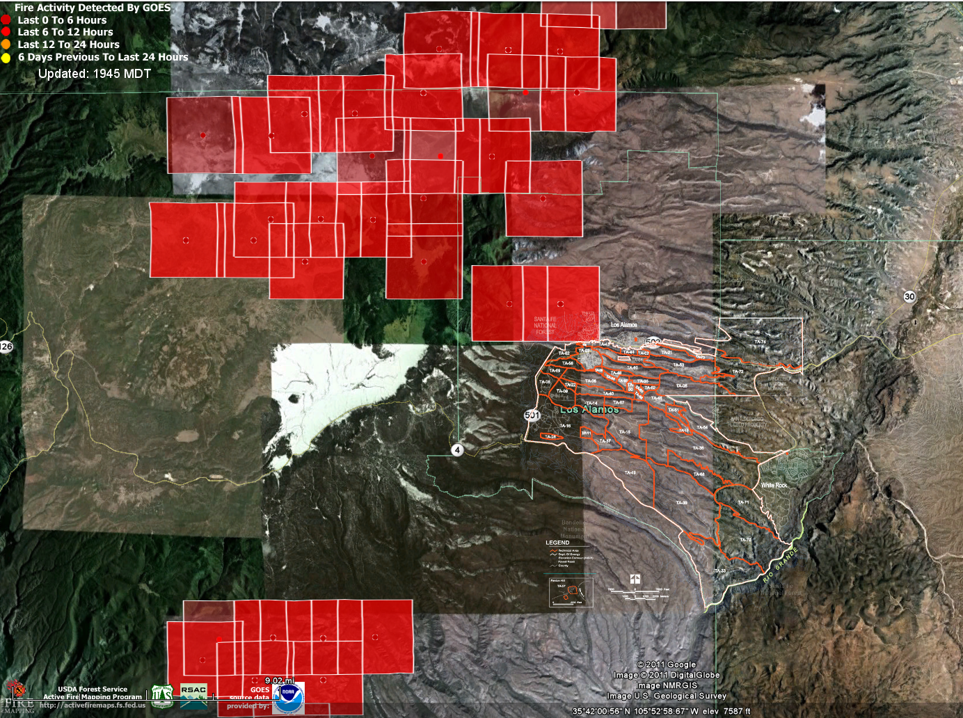
Friday 7/1/2011 I overlaid the MDA (Material Disposal Areas) and Technical Areas maps from Los Alamos Study Group on top of the GOES data set from the USDA Forest Service to get an idea of how far the Las Conchas wildfire had possibly encroached upon the LANL grounds, to see if the wildfire had possibly already contacted hazardous nuclear and/or chemical/explosive waste.
Here is the composite of the MDA and TA maps as one:

Here is the MDA+TA map overlaid on to the USDA Forest Service GOES data set:
 Disturbingly, some of the older GOES yellow fire detection squares above (the square shows a potentially affected area, not that it is actually on fire) span several Material Disposal Areas: MDA-M, MDA-F, MDA-C, MDA-Q, MDA-P, MDA-N, MDA-R, MDA-S, MDA-Z, MDA-Y, MDA-K Notice that the yellow dot where I am assuming the actual detection occurs falls almost right on top of MDA-Y in TA-39 (Southeast portion of map).
So far the press does not report fires actually reaching any hazardous materials and releasing radiation in to the air.
Here is the MDA+TA map overlaid on the USDA Forest Service MODIS data set:
 The MODIS data set shows older yellow detection squares being closest to MDA-M in TA-22, MDA-R in TA-16 and MDA-AB in TA-49.
Due to there not being many recent (red) detections close to the lab grounds it seems as if most of the danger has passed (at least according to GOES and MODIS). Most recent detections currently are primarily Northwest of Los Alamos National Lab.
Click here for previous maps from 7/1/2011 and source material (specific MDA and TA descriptions for example). Note that I only included 0-6 and 0-12 hour detections for that particular day as the older (yellow) detections are likely to be burnt out already.
Note that due to the top secret nature of Los Alamos National Lab, we do not know where all of the hazardous nuclear or chemical waste is located. Also, radiation can be released in to the air from burning trees which have grown near previous dump or test sites. Decades ago, barrels of nuclear waste were kicked-and-rolled in to unlined pits per Washington's Blog:
Friday 7/1/2011 I overlaid the MDA (Material Disposal Areas) and Technical Areas maps from Los Alamos Study Group on top of the GOES data set from the USDA Forest Service to get an idea of how far the Las Conchas wildfire had possibly encroached upon the LANL grounds, to see if the wildfire had possibly already contacted hazardous nuclear and/or chemical/explosive waste.
Here is the composite of the MDA and TA maps as one:

Here is the MDA+TA map overlaid on to the USDA Forest Service GOES data set:

So far the press does not report fires actually reaching any hazardous materials and releasing radiation in to the air.
Here is the MDA+TA map overlaid on the USDA Forest Service MODIS data set:

Due to there not being many recent (red) detections close to the lab grounds it seems as if most of the danger has passed (at least according to GOES and MODIS). Most recent detections currently are primarily Northwest of Los Alamos National Lab.
Click here for previous maps from 7/1/2011 and source material (specific MDA and TA descriptions for example). Note that I only included 0-6 and 0-12 hour detections for that particular day as the older (yellow) detections are likely to be burnt out already.
Note that due to the top secret nature of Los Alamos National Lab, we do not know where all of the hazardous nuclear or chemical waste is located. Also, radiation can be released in to the air from burning trees which have grown near previous dump or test sites. Decades ago, barrels of nuclear waste were kicked-and-rolled in to unlined pits per Washington's Blog:
...Following is a good (but several days old) interview with theoretical physicist Dr. Michio Kaku by KOATTV Action 7 News:
For many years, one method of disposal was “kick-and-roll”. The back of a truck was brought to the edge of a hole and barrels of waste were kicked. Wherever the barrels rolled tow as their final resting place.
...
Friday, July 1, 2011
7/1/2011 Wildfire distance to toxic (nuclear and otherwise) waste dumps on Los Alamos National Lab grounds
Date: 7/1/2011
Below is the MDA (Materials Disposal Areas) map from the Los Alamos Study Group website. For a detailed description of each MDA click on the map:
To visit this map page directly click here
The USDA Forest Service provides wildfire detection data which can be downloaded and viewed in Google Maps. In order to see the distance between the Las Conchas wildfire to the nuclear (or chemical/explosive) waste dump sites on the grounds of the Los Alamos National Lab I overlaid the inverted image of the above map on top of the Google Map with the fire detections data from the USDA Forest Service. Since the overlaid image is inverted (for better clarity) the original MDA map colors are transformed from red=>blue, green=>red, black=>white etc.
Here is the composite map, showing only detections 0-6 hours old (darker red) or 6-12 hours old (lighter red):
 The data set I used was for GOES and obtained by clicking the "Current" link next to "Fire Detections:".
There is a light red square (6-12 hour old detection) just about touching the biggest blue blob (biggest red blob from the original Los Alamos Study Group Map).
Following is the Technical Area map from Los Alamos Study Group:
To visit this map page directly click here
I did a similar overlay of the technical areas on top of the 0-6 hour and 0-12 hour fire detections:
 The light red square (6-12 hour old detection) is right on the North edge of TA-82, TA-03 and TA-43.
Finally here is the composite that combines the MDA (Material Disposal Areas) map with the Technical Areas map:
Below is the MDA (Materials Disposal Areas) map from the Los Alamos Study Group website. For a detailed description of each MDA click on the map:
To visit this map page directly click here
The USDA Forest Service provides wildfire detection data which can be downloaded and viewed in Google Maps. In order to see the distance between the Las Conchas wildfire to the nuclear (or chemical/explosive) waste dump sites on the grounds of the Los Alamos National Lab I overlaid the inverted image of the above map on top of the Google Map with the fire detections data from the USDA Forest Service. Since the overlaid image is inverted (for better clarity) the original MDA map colors are transformed from red=>blue, green=>red, black=>white etc.
Here is the composite map, showing only detections 0-6 hours old (darker red) or 6-12 hours old (lighter red):

There is a light red square (6-12 hour old detection) just about touching the biggest blue blob (biggest red blob from the original Los Alamos Study Group Map).
Following is the Technical Area map from Los Alamos Study Group:
To visit this map page directly click here
I did a similar overlay of the technical areas on top of the 0-6 hour and 0-12 hour fire detections:
Finally here is the composite that combines the MDA (Material Disposal Areas) map with the Technical Areas map:
Thursday, June 30, 2011
6/30/2011 Where those 30,000 55-gallon drums of plutonium contaminated waste were headed
Date: 6/30/2011
The following video from KOATV New Mexico (channel 7) reports on the WIPP (Waste Isolation Pilot Plant) 26 miles Southeast of Carlsbad, New Mexico: [1]
Los Alamos National Lab sends some it's nuclear waste here. The 30000 55-gallon drums of radioactive plutonium contaminated waste sitting above ground under cloth tents, as mentioned in various news stories, was/is slated to be delivered to this Carlsbad WIPP site. Quoting the AP:
[1] (Video) A Look At The WIPP Facility, KOATV New Mexico (Channel 7) YouTube Channel
[2] Wildfire shuts Los Alamos lab, forces evacuations, Associated Press
The following video from KOATV New Mexico (channel 7) reports on the WIPP (Waste Isolation Pilot Plant) 26 miles Southeast of Carlsbad, New Mexico: [1]
Los Alamos National Lab sends some it's nuclear waste here. The 30000 55-gallon drums of radioactive plutonium contaminated waste sitting above ground under cloth tents, as mentioned in various news stories, was/is slated to be delivered to this Carlsbad WIPP site. Quoting the AP:
...Sources:
The anti-nuclear watchdog group Concerned Citizens for Nuclear Safety, however, said the fire appeared to be about 3 1/2 miles from a dumpsite where as many as 30,000 55-gallon drums of plutonium-contaminated waste were stored in fabric tents above ground. The group said the drums were awaiting transport to a low-level radiation dump site in southern New Mexico.
Lab spokesman Steve Sandoval declined to confirm that there were any such drums currently on the property. He acknowledged that low-level waste is at times put in drums and regularly taken from the lab to the Waste Isolation Pilot Project site in Carlsbad. [2]
...
[1] (Video) A Look At The WIPP Facility, KOATV New Mexico (Channel 7) YouTube Channel
[2] Wildfire shuts Los Alamos lab, forces evacuations, Associated Press
Wednesday, June 29, 2011
6/28/2011 (Video) Obama to increase nuclear weapons production/refit plus wildfire threatens Los Alamos National Lab
Source: Democracy Now (I extracted the relevant video segment for relevance/brevity)
Date: 6/28/2011
The following Democracy Now interview with Greg Mello, leader of Los Alamos Study Group, not only warns that the Los Conchas wildfire in New Mexico threatens nuclear waste stored on the grounds of the Los Alamos National Laboratory, but also sheds light on the fact that the Obama administration is actually increasing nuclear weapons production/upgrades. I knew that Obama was an advocate of nuclear power for energy production but did not realize he was actually working towards increasing/upgrading America's current nuclear weapons arsenal. As part of this effort, Los Alamos National Lab will build a new $6 billion facility for the production of plutonium.
Visit Democracy Now for interview transcript and full video
Date: 6/28/2011
The following Democracy Now interview with Greg Mello, leader of Los Alamos Study Group, not only warns that the Los Conchas wildfire in New Mexico threatens nuclear waste stored on the grounds of the Los Alamos National Laboratory, but also sheds light on the fact that the Obama administration is actually increasing nuclear weapons production/upgrades. I knew that Obama was an advocate of nuclear power for energy production but did not realize he was actually working towards increasing/upgrading America's current nuclear weapons arsenal. As part of this effort, Los Alamos National Lab will build a new $6 billion facility for the production of plutonium.
Visit Democracy Now for interview transcript and full video
6/28/2011 How close is wildfire to nuclear waste at Los Alamos National Lab?
Source: Godlike Productions via Japan Pub Thinktank (Facebook Group)
by: Anonymous Coward
Disclaimer: This is a message board post and has not been fact checked
by: Anonymous Coward
Disclaimer: This is a message board post and has not been fact checked
| 6/28/11 -- LOS ALAMOS FIRE MAP -- shows just how close the fire is to some serious waste! | |
I came across the most recent survey map of the wildfire in Los Alamos at the following site: [link to wildfiretoday.com] I thought it would be informative to overlay this map with a map showing the technical areas (TAs) and material disposition areas (MDAs) on the Los Alamos National Lab reservation. Check this out: [link to www.flickr.com] The fire is located within the hatched orange outline shown in the lower left-hand corner of the picture. I don't know the exact scale of this map but it is about 11 miles from Los Alamos to White Rock so that should give you some sense of distance. It appears that the fire, as of June 28th, is about a mile or so from TA-16 and TA-28. TA-16 is a tritium and high explosives processing facility according to: [link to www.lasg.org] TA-28 is an explosives storage area. As far as the MDAs go, the fire is closest to MDA-R, MDA-S, MDA-Z and MDA-AB. These contain various toxic metals, organics, high explosives and radioactive wastes mostly buried in pits. All of those 30,000 drums of low-level radioactive waste we have been hearing about are in MDA-G, which is further away from the fire at the moment. But, oddly, what we haven't heard much about is the storage site for transuranic waste which is in MDA-C. This one is a little scary. Here is the description from the LASG site: ------------------------------------------------ [link to www.lasg.org] Location: Technical Area (TA) -50 Period of use: Pits (6): June 1948 to December 1964 Shafts (107): 1958 to April 1974 Size: 11.8 acres Number and type of disposal units: Pits 1- 4: 610 by 40 feet Pit 5: 705 by 110 feet by about 18 feet Pit 6: 505 by 100 feet by about 23 feet Chemical pit: 180 by 25 feet by about 12 feet Vary between 1 to 2 feet in diameter, and 10 to 25 feet deep Specific wastes and quantities: Estimated Volume: 3,186,000 ft3 of TRU waste Pits contain, as of January 1973: 25 Curies (Ci) of uranium 26 Ci of plutonium-239 149 Ci of americium-241 Shafts contain: 49,136 Ci of tritium 40 Ci sodium-22 20 Ci of cobalt-60 31 Ci of strontium-90 5 Ci of uranium-233 50 Ci fission products 200 Ci of induced activity Also contains quantities of mercury, copper, cobalt, boron, beryllium, and silver. (2) Potential environmental impacts: Lies near Ten-Site Canyon New Mexico Environment Department's (NMED) Hazardous and Radioactive Material Bureau (HRMB) ranks this MDA as an area with a high probability of contaminant mobilization and a moderate to high potential of release to the groundwater. -------------------------------------------------- That is an insane amount of highly radioactive waste. And notice at the end there that it is ranked as HIGH probability of contaminant mobilization! Just a heads up for you guys. We really need to watch this thing! | |
Monday, June 27, 2011
6/27/2011 Activist group warns Los Alamos wildfire 3 1/2 miles from dumpsite with plutonium-contaminated waste
Date: 6/27/2011
A serious New Mexico wildfire 78 square miles in size has forced a mandatory evacuation of the town of Los Alamos, which is where Los Alamos National Laboratory is located.[1] This laboratory is one of the three sites where the secret Manhattan Project was conducted resulting in the development of the world's first atomic bomb, as well as the hydrogen bomb. At the time, the responsibility of Los Alamos National Laboratory was weapons research and design.
According to the AP an activist group called Concerned Citizens for Nuclear Safety warned that the wildfire is 3.5 miles away from 30,000 55-gallon drums of plutonium-contaminated waste stored on the grounds of the Los Alamos National Laboratory:
Nightly News with Brian Williams [2]
Sources:
[1] Wildfire Shuts Los Alamos Lab, Forces Evacuations, AP via ABC News
[2] (VIDEO) Nightly News with Brian Williams, MSNBC
A serious New Mexico wildfire 78 square miles in size has forced a mandatory evacuation of the town of Los Alamos, which is where Los Alamos National Laboratory is located.[1] This laboratory is one of the three sites where the secret Manhattan Project was conducted resulting in the development of the world's first atomic bomb, as well as the hydrogen bomb. At the time, the responsibility of Los Alamos National Laboratory was weapons research and design.
According to the AP an activist group called Concerned Citizens for Nuclear Safety warned that the wildfire is 3.5 miles away from 30,000 55-gallon drums of plutonium-contaminated waste stored on the grounds of the Los Alamos National Laboratory:
...The media contact for Los Alamos National Lab when asked refused to confirm the statement by Concerned Citizens for Nuclear Safety:
The anti-nuclear watchdog group Concerned Citizens for Nuclear Safety, however, said the fire appeared to be about 3 1/2 miles from a dumpsite where as many as 30,000 55-gallon drums of plutonium-contaminated waste were stored in fabric tents above ground. The group said the drums were awaiting transport to a low-level radiation dump site in southern New Mexico.[1]
...
...The wildfire has already encroached upon the grounds of Los Alamos National Lab, having burned part of Tech Area 49, which in the 1960's was used to conduct underground testing of high explosives and radioactive materials.[1]
Lab spokesman Steve Sandoval declined to confirm that there were any such drums currently on the property. He acknowledged that low-level waste is at times put in drums and regularly taken from the lab to the Waste Isolation Pilot Project site in Carlsbad.[1]
...
Nightly News with Brian Williams [2]
Sources:
[1] Wildfire Shuts Los Alamos Lab, Forces Evacuations, AP via ABC News
[2] (VIDEO) Nightly News with Brian Williams, MSNBC
Subscribe to:
Posts (Atom)